Milestone-Proposal:LORAN: Difference between revisions
From ETHW
(Article updated via HTTP request) |
(Article updated via HTTP request) |
||
| Line 1: | Line 1: | ||
{{ProposalEdit|a1=LORAN|a2a=Cambridge MA|a2b=Boston Section|a3=1940 to 1946|a4=What exactly is proposed? Not for any one single invention but for the design, development, building and launching of a near global radio navigation system in the 1940s,that originated from Cambridge Massachusetts, that helped turn the course of the war in Europe and in the Pacific, that Within a matter of years, a complex radio navigation system called loran went on the air to create e a network for ship- borne navigators to find their way across the North Atlantic. | {{ProposalEdit|a1=LORAN|a2a=Cambridge MA|a2b=Boston Section|a3=1940 to 1946|a4=What exactly is proposed? Not for any one single invention but for the design, development, building and launching of a near global radio navigation system in the 1940s,that originated from Cambridge Massachusetts, that helped turn the course of the war in Europe and in the Pacific, that Within a matter of years, a complex radio navigation system called loran went on the air to create e a network for ship- borne navigators to find their way across the North Atlantic. Using the same technology,during the same period, the radio navigation system was extended for coverage in the Pacific Ocean. Loran was a totally new American system of navigation pressed into service during the 1940s used by thousands of navigators over three-tenths of te surface of the earth (1946). | ||
The Boston Section is proposing the LORAN Milestone because system design and development took place in Cambridge during 1940 to 1946. Engineering was under the direction of the Radiation Laboratory of the Massachusetts Institute of Technology. | |||
The Boston Section is proposing the LORAN Milestone because system design and development took place in Cambridge during 1940 to 1946. | |||
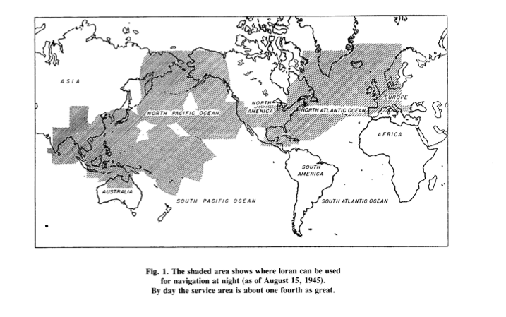
This illustrates the coverage provided by loran in 1946: | This illustrates the coverage provided by loran in 1946: | ||
INSERT CHART 1946 | INSERT CHART 1946 | ||
| Line 19: | Line 18: | ||
Mangersta, Hebribes - RN | Mangersta, Hebribes - RN | ||
Sankaty, Nantucket, MA (monitoring station) - USGC | Sankaty, Nantucket, MA (monitoring station) - USGC | ||
See USGC website on the history ... | See USGC website on the history ... | ||
The building of loran in the Pacific is | The building of loran in the Pacific is accomplished by MIT's Rad Lab and the USCG. The Rad Lab's direct involvement deminised as ... | ||
A Loran School was established for training of loran radio technicians on MIT campus. The school was relocated gto Boston and later to CT. | |||
"But it was in the Pacific that Loran made its greatest direct contribution to winning the war. Distances in the Pacific Ocean are enormous. As American forces moved westward, air fields were built on many of the small islands and atolls that dot the ocean beyond Hawaii. The limited range of many World War II aircraft demanded that they frequently land and refuel. Navigation by celestial observations is possible only when weather permits and, moreover, it requires a highly trained man who does little on the plane except navigate. Because of the lengthy training required, celestial navigators, particularly on Army Air Corps planes, were extremely scarce. Thus it was that loran provided the easy-to-use, accurate navigational system required to and the air fields so necessary for refueling." (*) | "But it was in the Pacific that Loran made its greatest direct contribution to winning the war. Distances in the Pacific Ocean are enormous. As American forces moved westward, air fields were built on many of the small islands and atolls that dot the ocean beyond Hawaii. The limited range of many World War II aircraft demanded that they frequently land and refuel. Navigation by celestial observations is possible only when weather permits and, moreover, it requires a highly trained man who does little on the plane except navigate. Because of the lengthy training required, celestial navigators, particularly on Army Air Corps planes, were extremely scarce. Thus it was that loran provided the easy-to-use, accurate navigational system required to and the air fields so necessary for refueling." (*) | ||
ADD WORDS ABOUT PLANES | ADD WORDS ABOUT PLANES | ||
Revision as of 21:16, 12 December 2010
This Proposal has not been submitted and may only be edited by the original author.
Pierce Loran.pdf
Loran1.jpg .png
Loran_chart.png
This is a test