Milestone-Proposal:LORAN: Difference between revisions
(Article updated via HTTP request) |
No edit summary |
||
| (70 intermediate revisions by 3 users not shown) | |||
| Line 1: | Line 1: | ||
{{ | {{Proposal | ||
|docketid=2010-10 | |||
|a11=No | |||
|a3=1940 to 1946 | |||
|a1=LORAN | |||
|a2b=Boston Section | |||
|IEEE units paying={{IEEE Organizational Unit Paying | |||
|Unit=Boston Section | |||
|Senior officer name=Robert Alongi | |||
|Senior officer email=sec.boston@ieee.org | |||
}} | |||
|IEEE units arranging={{IEEE Organizational Unit Arranging | |||
|Unit=Boston Section | |||
|Senior officer name=Robert Alongi | |||
|Senior officer email=sec.boston@ieee.org | |||
}} | |||
|IEEE sections monitoring={{IEEE Section Monitoring | |||
|Section=Boston Section | |||
|Section chair name=Bruce Hecht | |||
}} | |||
|Milestone proposers={{Milestone proposer | |||
|Proposer name=Gilmore Cooke | |||
|Proposer email=gilcooke@ieee.org | |||
}} | |||
|a2a=Cambridge MA | |||
|a7=The Hood building is not a suitable place for the proposed IEEE plaque. Instead, the loran milestone plaque could probably be mounted alongside the other IEEE milestone plaques at MIT Building N42, 211 Massachusetts Avenue. The Boston Milestone Committee will seek their approval from MIT and proceed accordingly. | |||
|a8=No | |||
|a9=The proposed plaque would be be wall-mounted outdoors, probably attached to MIT Building N42, alongside other plaques at 211 Massachusetts Avenue. The plaque would be readily visible to pedestrians walking on this public sidewalk. | |||
|a10=MIT | |||
|a4=Radiation Laboratory of the Massachusetts Institute of Technology: | |||
In October 1940, MIT was chosen for the site of an independent laboratory that would be staffed by civilian and academic scientists from every discipline. Fourteen months before the U.S. entered World War II, MIT formed, under government contract, a newly Radiation Laboratory began its investigation of radio navigation and radar. The radio navigation division was housed separately from the radar group but was always referred to as Radiation Laboratory. The staff was housed in their own building in Cambridge. On 31 December 1945, the Radiation Laboratory was formally closed and staff members returned to their careers. It should be noted that in 1990, the IEEE Milestone was awarded to the Radiation Laboratory. That Milestone was awarded to the laboratory as a whole, not navigation. | |||
Our Proposal: | |||
The Boston Section wants to nominate the LORAN system of navigation for IEEE Milestone. Loran was a large engineered system, built from scratch and completed in the 1940s. Now, over sixty years later, every mariner in the world have used or know loran. The word stands for long-range navigation. Loran was a totally American system of navigation quickly developed during the Second World War. By 1946, loran was used by thousands of navigators over three-tenths of the surface of the earth. Loran is a hyperbolic system of navigation based on pulse-modulated synchronized signals. More details will be given elsewhere in this document. | |||
The proposal recognizes the many different organizations involved in building the loran system. Military personnel, scientists, engineers, fabricators, technicians, radio operators, all had roles in getting loran on the air. However, the proposed milestone nomination is limited to those activities carried by Rad Lab employees in the US or on assignments off shore. Plans, scientific research, tests, even a few of the early transmitters were fabricated in the shop in Cambridge. Radio technicians and navigators were trained here in Boston. After attending Loran School, they would return to their assigned transmitter station, ship, or aircraft. This is why members of the Boston Section of the IEEE wish to commemorate loran as IEEE Milestone. | |||
Navigation Division and Key Individuals: | |||
At its peak level of staffing, there were about 60 people in the radio navigation or loran division: scientists, academics, engineers, and technicians. Their job was research, design, plan, engineer, and develop a whole new system of navigation called loran – long-range navigation system. For a short period of time, the staff had to operate and man the first two transmitting stations. Melville Eastman managed the division from 1941 to 1943. Eastman, CEO and founder of General Radio Corporation of Cambridge, was on leave from his company during that period. Donald G Fink replaced him on March 1943. Donald G Fink worked at the MIT Radiation Laboratory and traveled overseas installing loran sites. Fink had a long association with the Institute of Radio Engineers and was president of the IRE in 1958. | |||
The chief researcher and scientist was JA (Jack) Pierce, a scientist fellow from Harvard University, Cambridge. He joined the team in 1941. Later in his career, Pierce would receive the Medal For Engineering Excellence for the design, teaching and advocacy of radio propagation, navigation and timing. His work led to the development of Loran, Loran C and other systems. | |||
a | |||
Monitoring the project and coordinating with superiors in Washington DC was Lawrence M. Harding, a senior officer in the United States Coast Guard (USCG). In 1942 he was transferred to Cambridge to coordinate with US Navy and government agencies. It was he who came up with the name LORAN derived from long-range navigation. Harding played an important role in surveys, logistics, equipment transportation, and building loran stations along the Atlantic coasts. By 1943, Harding and the Coast Guards were able get some twenty-five loran transmitter stations erected and running in the Aleutian Islands and the Pacific. | |||
By | |||
LORAN | The Significance of the Loran Project: | ||
Loran was a completely new American system of navigation, developed and quickly pressed into service during the war. By 1946, loran was used by thousands of navigators over three-tenths of the surface of the earth. Loran was and still is a hyperbolic system of navigation based on pulse-modulated synchronized signals. More details will be given elsewhere in this document. | |||
The extent of loran coverage available to navigators in 1946 is illustrated in Figure 1. The North Atlantic Chain was given first priority to allow ship convoys to find their way across treacherous waters. During wartime, Loran had the advantage of allowing ships to maintain radio silence. | |||
[[Image:Loran1.jpg .png|center]] | |||
The North Atlantic: | |||
Loran Radiation Laboratory personnel were heavily involved with research and development of the North Atlantic Chain. The first Loran-A pair was on the air permanently by June 1942 (Montauk Point, NY, and Fenwick Is, Del.), and by October there were additional stations along the Canadian east coast. The system became operational in early 1943, and late that year stations were established in Greenland, Iceland, the Faeroes and the Hebrides to complete the North Atlantic cover. Loran stations were manned by the United States Coast Guard (USCG), Royal Canadian Navy (RCN), and the Royal Navy (RN). At the request of the RAF, another station was put into the Shetlands to cover Norway, and loran was eventually used by over 450 aircraft of Coastal Command. | |||
By 1944, the North Atlantic Chain consisted of the following loran stations. The name of the organization operating the station is identified. | |||
Fenwick Island, Delaware, DE - USCG<br> | |||
Mantauk Point, Long Island NY - USCG<br> | |||
Baccaro, Nova Scotia, Canada - RCN<br> | |||
Deming, Nova Scotia, Canada - RCN<br> | |||
Bona Vista, Newfoundland - USCG<br> | |||
Bath Harbor, Labrador - USCG<br> | |||
Frederiks, Greenland - USCG<br> | |||
Vik Island - RN<br> | |||
Skuvanes Head, Faeroe Island - RN<br> | |||
Mangersta, Hebribes - RN<br> | |||
Sankaty, Nantucket, MA (monitoring station) - USCG<br> | |||
Aleutian Island and the Pacific Ocean: | |||
In the summer of 1943, the United States Coast Guards completed the first independent installation of loran transmitting stations in the Aleutian Island. The equipment in this case had been quickly fabricated in the shop in Cambridge, as Naval procurement had not yet come into effect. The Coast Guards continued the work and installed twenty-five stations in the Pacific, climaxing its efforts with stations at Jima and Okinawa, which were erected closely on the heels of the invading forces. Of special significance in the Pacific warfare were stations in the Marianas, which provided very effective guidance for the 20th Air Force in its bombing of Japan. | |||
Loran made its greatest direct contribution to winning the war because distances in the Pacific Ocean are enormous. As American forces moved westward, airfields were built on many of the small islands. The limited range of many World War II aircraft demanded that they frequently land and refuel. Loran provided the easy-to-use, accurate navigational system to locate airfields and land for refueling. | |||
An Extreme Radio Engineering Project: | |||
At the end of the war some seventy loran-transmitting stations were in operations providing nighttime service over 60 million square miles or three tenths of the earth’s surface. Pierce, in his article, reported that by 1946, 75,000 ship-borne and air-borne navigator’s receivers had been delivered by the various American manufactures. He also reports that the Hydrographic Office, which had been preparing the required loran charts for nautical navigation, had shipped two-and-a-quarter million charts to various operating agencies. | |||
References Used: | |||
1. JA Pierce, "An Introduction to Loran", Proceeding of the IRE, 1946. Reprinted by IEEE AES Magazine 1990 (see attached).<br> | |||
2. Bowditch, American Practical Navigator. U.S. Navy Hydrographic Office, 1958 pp. 333 – 343.<br> | |||
3. The Coast Guard at War: IV LORAN VOLUME II.<br> | |||
Prepared in the Historical Section Public Information Division U.S. Coast Guard Headquarters in 1 August 1946:<br> | |||
http://www.uscg.mil/History/STATIONS/loran_volume_2.asp<br> | |||
http://www.uscg.mil/history/stations/LORAN_Section_2.asp<br> | |||
http://www.uscg.mil/history/stations/LORAN_Volume_1_Index.asp<br> | |||
4. Other Websites:<br> | |||
http://www.loran-history.info/<br> | |||
http:/ www.jproc.ca/hyperbolic/loran_a.html <br> | |||
http://en.wikipedia.org/wiki/LORAN | |||
To Probe Further: | |||
Willoughy, Malcolm Francis; The Story of LORAN in the U.S. Coast Guard in World War II, Arno Pro, 1980. | |||
|a6=Obstacles during the course of the project were accepted as is or resolved. Secrecy had to be maintained throughout, probably making things worst. The following conditions or obstacles had to be dealt with: | |||
1. Loran stations were often in remote isolated area, making field construction difficult. | |||
2. Cooperation among different countries was required: Canada, Denmark, and Britain, for example. | |||
3. High reliability requirements: In his article, Pierce describes the features taken into account during the design because of high requirements for continuous service. He states that the transmitters worked satisfactorily within specified limits “99 percent of the times”. That's pretty impressive for first generation equipment, considering that loran transmitters are synchronized and operate in pairs. Because the time at which the slave pulse reaches the master station is known, the master station continuously monitors the slave pulse. If a discrepancy is detected, the master alerts the slave station. Either station can initiate a trouble alarm to navigators warning of a potential problem. | |||
To simplify maintenance, all units were in duplicate with provisions for quick interchange of operating and stand-by units. Overlapping coverage, multiple timers, were provided. Shielded rooms were used to protect timers from interferences. | |||
4. Living at remote isolated loran stations: Loran stations were often isolated, remote, dreary places. One website explains as follows: | |||
"The crews of loran stations varied somewhat in size, depending on their locations. They have averaged about fifteen men. As the stations had to be entirely self-sufficient, they had cooks, hospital corpsmen, in addition to the electronic technicians who operated and maintained the transmitters. Each station was commanded by a commissioned officer, usually a lieutenant, with a chief petty officer as second in command. Prospective commanding officers were given a short training course in loran and administration before assignment. Many young men dreaded loran duty because of the isolation, but after it is over, nearly all of them felt it had been well worthwhile. At isolated stations, tours of duty were for one year. The great majority of loran stations were supplied with fuel, bulky spare parts, and large staple items by a Coast Guard supply ship, which called once or twice a year. Unless they were located near a large community, loran stations received mail; personnel, fresh stores, and emergency spare parts by Coast Guard airplane. Most stations had their own airstrip." | |||
5. Training operators and navigators: A great number of radio operators and technicians from the US and other countries had to be trained on how to operate the new navigation transmitters. Additionally, navigators aboard ships and aircrafts had to learn a whole new way of doing things to find their fix. | |||
|a5=Loran is a hyperbolic system of navigation by which difference in distance from two points on shore is determined by measurement of the time interval between receptions of pulse- modulated synchronized signals from transmitters at the two points. Both ground waves and sky waves can be used to provide coverage over an extensive area with few stations, depending on design frequencies. An important advantage of loran at the time of its development during World War 2 was that a ship could use loran without breaking radio silence. Loran transmitting stations work in pairs. Synchronization is achieved by letting the signals of the master station, control those of the slave station. To help overcome the disadvantage of requiring two transmitting stations for a single family of hyperbolic lines of positions, loran forms a chain of stations, so that each station except the end ones operate with the station on either side to form an intersecting lattice of position lines. To find his way, a loran navigator on a ship had to be trained, have a loran receiver-indicator, and a set of loran nautical charts or loran tables. Standard loran was initially developed primarily for navigation over water. It was also used for air-borne navigation. | |||
[[Image:Loran chart.png|center]] | |||
Today's loran operates on one of several frequencies between1700 and 2000 kHz. It enjoys propagation characteristics determined primarily by soil conductivity and ionosphere conditions. Both ground wave and sky waves can be used to provide coverage over an extensive area with few stations. Usually, stations of a pair are located 200 to 400 miles or more. At one time, 1000 to 1400 miles apart separated several station pairs. Transmitters now in use radiate about 100kw and give a ground-wave range over seawater of about 700 nautical miles in the daytime. The daytime range over land is seldom more than 250 miles even for high-flying aircraft and is scarcely 100miles at the surface of the earth. At night the ground-wave range oversea water is reduced to about 500 miles by the increase in atmospheric noise, but sky waves, which are almost completely absorbed by day, become effective and increase the reliable night range to about 1400miles. Generally, a number of stations are located so as to form a chain, with all but the end station in the group being double pulsing. In most parts of the world, signals can be received from at least two pairs of stations making it possible for a mariner to determine a fix using loran alone. | |||
[[Media:Pierce Loran.pdf|A full and complete description of the evolution of loran is provided in the attached article by JA Pierce entitled "An Introduction to Loran"]] | |||
|submitted=No | |||
|a12=The Boston Section with support from local Society Chapters, and financial contributions from sponsors. | |||
|a13name=Bruce Hecht | |||
|a13section=Boston | |||
|a13position=2010 Chair | |||
|a13email=Bruce Hecht | |||
|a14name=Robert Alongi | |||
|a14ou=Boston Section | |||
|a14position=Section Business Manager | |||
|a14email=sec.boston@ieee.org | |||
|a15Aname=Gilmore Cooke | |||
|a15Aemail=gilcooke@ieee.org | |||
|a15Aname2= | |||
|a15Aemail2= | |||
|a15Bname=c/o Robert Alongi | |||
|a15Bemail=sec.boston@ieee.org | |||
|a15Bname2=To be assigned later | |||
|a15Bemail2= | |||
|a15Cname=Gilmore Cooke | |||
|a15Ctitle=retired PE | |||
|a15Corg=Boston Section Executive Committee | |||
|a15Caddress=8 Canvasback, W. Yarmouth, MA 02673 | |||
|a15Cphone=617-759-4271 | |||
|a15Cemail=gilcooke@ieee.org | |||
}} | |||
<br>[[Media:Loran1.jpg_.png|Loran1.jpg .png]] | |||
Latest revision as of 20:01, 17 July 2012
Docket #:2010-10
This Proposal has been approved, and is now a Milestone Nomination
This is a draft proposal, that has not yet been submitted. To submit this proposal, click on "Edit with form", check the "Submit this proposal for review" box at the bottom, and save the page.
Is the achievement you are proposing more than 25 years old?
Is the achievement you are proposing within IEEE’s fields of interest? (e.g. “the theory and practice of electrical, electronics, communications and computer engineering, as well as computer science, the allied branches of engineering and the related arts and sciences” – from the IEEE Constitution)
Did the achievement provide a meaningful benefit for humanity?
Was it of at least regional importance?
Has an IEEE Organizational Unit agreed to pay for the milestone plaque(s)?
Has an IEEE Organizational Unit agreed to arrange the dedication ceremony?
Has the IEEE Section in which the milestone is located agreed to take responsibility for the plaque after it is dedicated?
Has the owner of the site agreed to have it designated as an Electrical Engineering Milestone?
No
Year or range of years in which the achievement occurred:
1940 to 1946
Title of the proposed milestone:
LORAN
Plaque citation summarizing the achievement and its significance:
In what IEEE section(s) does it reside?
Boston Section
IEEE Organizational Unit(s) which have agreed to sponsor the Milestone:
IEEE Organizational Unit(s) paying for milestone plaque(s):
Unit: Boston Section
Senior Officer Name: Senior officer name masked to public
IEEE Organizational Unit(s) arranging the dedication ceremony:
Unit: Boston Section
Senior Officer Name: Senior officer name masked to public
IEEE section(s) monitoring the plaque(s):
IEEE Section: Boston Section
IEEE Section Chair name: Section chair name masked to public
Milestone proposer(s):
Proposer name: Proposer's name masked to public
Proposer email: Proposer's email masked to public
Please note: your email address and contact information will be masked on the website for privacy reasons. Only IEEE History Center Staff will be able to view the email address.
Street address(es) and GPS coordinates of the intended milestone plaque site(s):
Cambridge MA
Describe briefly the intended site(s) of the milestone plaque(s). The intended site(s) must have a direct connection with the achievement (e.g. where developed, invented, tested, demonstrated, installed, or operated, etc.). A museum where a device or example of the technology is displayed, or the university where the inventor studied, are not, in themselves, sufficient connection for a milestone plaque.
Please give the address(es) of the plaque site(s) (GPS coordinates if you have them). Also please give the details of the mounting, i.e. on the outside of the building, in the ground floor entrance hall, on a plinth on the grounds, etc. If visitors to the plaque site will need to go through security, or make an appointment, please give the contact information visitors will need.
The Hood building is not a suitable place for the proposed IEEE plaque. Instead, the loran milestone plaque could probably be mounted alongside the other IEEE milestone plaques at MIT Building N42, 211 Massachusetts Avenue. The Boston Milestone Committee will seek their approval from MIT and proceed accordingly.
Are the original buildings extant?
No
Details of the plaque mounting:
How is the site protected/secured, and in what ways is it accessible to the public?
The proposed plaque would be be wall-mounted outdoors, probably attached to MIT Building N42, alongside other plaques at 211 Massachusetts Avenue. The plaque would be readily visible to pedestrians walking on this public sidewalk.
Who is the present owner of the site(s)?
MIT
A letter in English, or with English translation, from the site owner(s) giving permission to place IEEE milestone plaque on the property:
A letter or email from the appropriate Section Chair supporting the Milestone application:
What is the historical significance of the work (its technological, scientific, or social importance)?
Radiation Laboratory of the Massachusetts Institute of Technology: In October 1940, MIT was chosen for the site of an independent laboratory that would be staffed by civilian and academic scientists from every discipline. Fourteen months before the U.S. entered World War II, MIT formed, under government contract, a newly Radiation Laboratory began its investigation of radio navigation and radar. The radio navigation division was housed separately from the radar group but was always referred to as Radiation Laboratory. The staff was housed in their own building in Cambridge. On 31 December 1945, the Radiation Laboratory was formally closed and staff members returned to their careers. It should be noted that in 1990, the IEEE Milestone was awarded to the Radiation Laboratory. That Milestone was awarded to the laboratory as a whole, not navigation.
Our Proposal:
The Boston Section wants to nominate the LORAN system of navigation for IEEE Milestone. Loran was a large engineered system, built from scratch and completed in the 1940s. Now, over sixty years later, every mariner in the world have used or know loran. The word stands for long-range navigation. Loran was a totally American system of navigation quickly developed during the Second World War. By 1946, loran was used by thousands of navigators over three-tenths of the surface of the earth. Loran is a hyperbolic system of navigation based on pulse-modulated synchronized signals. More details will be given elsewhere in this document.
The proposal recognizes the many different organizations involved in building the loran system. Military personnel, scientists, engineers, fabricators, technicians, radio operators, all had roles in getting loran on the air. However, the proposed milestone nomination is limited to those activities carried by Rad Lab employees in the US or on assignments off shore. Plans, scientific research, tests, even a few of the early transmitters were fabricated in the shop in Cambridge. Radio technicians and navigators were trained here in Boston. After attending Loran School, they would return to their assigned transmitter station, ship, or aircraft. This is why members of the Boston Section of the IEEE wish to commemorate loran as IEEE Milestone.
Navigation Division and Key Individuals:
At its peak level of staffing, there were about 60 people in the radio navigation or loran division: scientists, academics, engineers, and technicians. Their job was research, design, plan, engineer, and develop a whole new system of navigation called loran – long-range navigation system. For a short period of time, the staff had to operate and man the first two transmitting stations. Melville Eastman managed the division from 1941 to 1943. Eastman, CEO and founder of General Radio Corporation of Cambridge, was on leave from his company during that period. Donald G Fink replaced him on March 1943. Donald G Fink worked at the MIT Radiation Laboratory and traveled overseas installing loran sites. Fink had a long association with the Institute of Radio Engineers and was president of the IRE in 1958.
The chief researcher and scientist was JA (Jack) Pierce, a scientist fellow from Harvard University, Cambridge. He joined the team in 1941. Later in his career, Pierce would receive the Medal For Engineering Excellence for the design, teaching and advocacy of radio propagation, navigation and timing. His work led to the development of Loran, Loran C and other systems.
Monitoring the project and coordinating with superiors in Washington DC was Lawrence M. Harding, a senior officer in the United States Coast Guard (USCG). In 1942 he was transferred to Cambridge to coordinate with US Navy and government agencies. It was he who came up with the name LORAN derived from long-range navigation. Harding played an important role in surveys, logistics, equipment transportation, and building loran stations along the Atlantic coasts. By 1943, Harding and the Coast Guards were able get some twenty-five loran transmitter stations erected and running in the Aleutian Islands and the Pacific.
The Significance of the Loran Project:
Loran was a completely new American system of navigation, developed and quickly pressed into service during the war. By 1946, loran was used by thousands of navigators over three-tenths of the surface of the earth. Loran was and still is a hyperbolic system of navigation based on pulse-modulated synchronized signals. More details will be given elsewhere in this document.
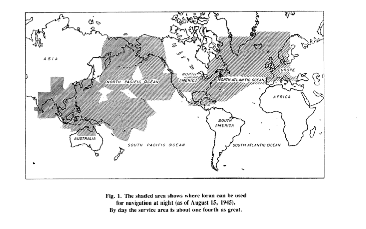
The extent of loran coverage available to navigators in 1946 is illustrated in Figure 1. The North Atlantic Chain was given first priority to allow ship convoys to find their way across treacherous waters. During wartime, Loran had the advantage of allowing ships to maintain radio silence.

The North Atlantic:
Loran Radiation Laboratory personnel were heavily involved with research and development of the North Atlantic Chain. The first Loran-A pair was on the air permanently by June 1942 (Montauk Point, NY, and Fenwick Is, Del.), and by October there were additional stations along the Canadian east coast. The system became operational in early 1943, and late that year stations were established in Greenland, Iceland, the Faeroes and the Hebrides to complete the North Atlantic cover. Loran stations were manned by the United States Coast Guard (USCG), Royal Canadian Navy (RCN), and the Royal Navy (RN). At the request of the RAF, another station was put into the Shetlands to cover Norway, and loran was eventually used by over 450 aircraft of Coastal Command.
By 1944, the North Atlantic Chain consisted of the following loran stations. The name of the organization operating the station is identified.
Fenwick Island, Delaware, DE - USCG
Mantauk Point, Long Island NY - USCG
Baccaro, Nova Scotia, Canada - RCN
Deming, Nova Scotia, Canada - RCN
Bona Vista, Newfoundland - USCG
Bath Harbor, Labrador - USCG
Frederiks, Greenland - USCG
Vik Island - RN
Skuvanes Head, Faeroe Island - RN
Mangersta, Hebribes - RN
Sankaty, Nantucket, MA (monitoring station) - USCG
Aleutian Island and the Pacific Ocean:
In the summer of 1943, the United States Coast Guards completed the first independent installation of loran transmitting stations in the Aleutian Island. The equipment in this case had been quickly fabricated in the shop in Cambridge, as Naval procurement had not yet come into effect. The Coast Guards continued the work and installed twenty-five stations in the Pacific, climaxing its efforts with stations at Jima and Okinawa, which were erected closely on the heels of the invading forces. Of special significance in the Pacific warfare were stations in the Marianas, which provided very effective guidance for the 20th Air Force in its bombing of Japan.
Loran made its greatest direct contribution to winning the war because distances in the Pacific Ocean are enormous. As American forces moved westward, airfields were built on many of the small islands. The limited range of many World War II aircraft demanded that they frequently land and refuel. Loran provided the easy-to-use, accurate navigational system to locate airfields and land for refueling.
An Extreme Radio Engineering Project:
At the end of the war some seventy loran-transmitting stations were in operations providing nighttime service over 60 million square miles or three tenths of the earth’s surface. Pierce, in his article, reported that by 1946, 75,000 ship-borne and air-borne navigator’s receivers had been delivered by the various American manufactures. He also reports that the Hydrographic Office, which had been preparing the required loran charts for nautical navigation, had shipped two-and-a-quarter million charts to various operating agencies.
References Used:
1. JA Pierce, "An Introduction to Loran", Proceeding of the IRE, 1946. Reprinted by IEEE AES Magazine 1990 (see attached).
2. Bowditch, American Practical Navigator. U.S. Navy Hydrographic Office, 1958 pp. 333 – 343.
3. The Coast Guard at War: IV LORAN VOLUME II.
Prepared in the Historical Section Public Information Division U.S. Coast Guard Headquarters in 1 August 1946:
http://www.uscg.mil/History/STATIONS/loran_volume_2.asp
http://www.uscg.mil/history/stations/LORAN_Section_2.asp
http://www.uscg.mil/history/stations/LORAN_Volume_1_Index.asp
4. Other Websites:
http://www.loran-history.info/
http:/ www.jproc.ca/hyperbolic/loran_a.html
http://en.wikipedia.org/wiki/LORAN
To Probe Further:
Willoughy, Malcolm Francis; The Story of LORAN in the U.S. Coast Guard in World War II, Arno Pro, 1980.
What obstacles (technical, political, geographic) needed to be overcome?
Obstacles during the course of the project were accepted as is or resolved. Secrecy had to be maintained throughout, probably making things worst. The following conditions or obstacles had to be dealt with:
1. Loran stations were often in remote isolated area, making field construction difficult.
2. Cooperation among different countries was required: Canada, Denmark, and Britain, for example.
3. High reliability requirements: In his article, Pierce describes the features taken into account during the design because of high requirements for continuous service. He states that the transmitters worked satisfactorily within specified limits “99 percent of the times”. That's pretty impressive for first generation equipment, considering that loran transmitters are synchronized and operate in pairs. Because the time at which the slave pulse reaches the master station is known, the master station continuously monitors the slave pulse. If a discrepancy is detected, the master alerts the slave station. Either station can initiate a trouble alarm to navigators warning of a potential problem.
To simplify maintenance, all units were in duplicate with provisions for quick interchange of operating and stand-by units. Overlapping coverage, multiple timers, were provided. Shielded rooms were used to protect timers from interferences.
4. Living at remote isolated loran stations: Loran stations were often isolated, remote, dreary places. One website explains as follows:
"The crews of loran stations varied somewhat in size, depending on their locations. They have averaged about fifteen men. As the stations had to be entirely self-sufficient, they had cooks, hospital corpsmen, in addition to the electronic technicians who operated and maintained the transmitters. Each station was commanded by a commissioned officer, usually a lieutenant, with a chief petty officer as second in command. Prospective commanding officers were given a short training course in loran and administration before assignment. Many young men dreaded loran duty because of the isolation, but after it is over, nearly all of them felt it had been well worthwhile. At isolated stations, tours of duty were for one year. The great majority of loran stations were supplied with fuel, bulky spare parts, and large staple items by a Coast Guard supply ship, which called once or twice a year. Unless they were located near a large community, loran stations received mail; personnel, fresh stores, and emergency spare parts by Coast Guard airplane. Most stations had their own airstrip."
5. Training operators and navigators: A great number of radio operators and technicians from the US and other countries had to be trained on how to operate the new navigation transmitters. Additionally, navigators aboard ships and aircrafts had to learn a whole new way of doing things to find their fix.
What features set this work apart from similar achievements?
Loran is a hyperbolic system of navigation by which difference in distance from two points on shore is determined by measurement of the time interval between receptions of pulse- modulated synchronized signals from transmitters at the two points. Both ground waves and sky waves can be used to provide coverage over an extensive area with few stations, depending on design frequencies. An important advantage of loran at the time of its development during World War 2 was that a ship could use loran without breaking radio silence. Loran transmitting stations work in pairs. Synchronization is achieved by letting the signals of the master station, control those of the slave station. To help overcome the disadvantage of requiring two transmitting stations for a single family of hyperbolic lines of positions, loran forms a chain of stations, so that each station except the end ones operate with the station on either side to form an intersecting lattice of position lines. To find his way, a loran navigator on a ship had to be trained, have a loran receiver-indicator, and a set of loran nautical charts or loran tables. Standard loran was initially developed primarily for navigation over water. It was also used for air-borne navigation.

Today's loran operates on one of several frequencies between1700 and 2000 kHz. It enjoys propagation characteristics determined primarily by soil conductivity and ionosphere conditions. Both ground wave and sky waves can be used to provide coverage over an extensive area with few stations. Usually, stations of a pair are located 200 to 400 miles or more. At one time, 1000 to 1400 miles apart separated several station pairs. Transmitters now in use radiate about 100kw and give a ground-wave range over seawater of about 700 nautical miles in the daytime. The daytime range over land is seldom more than 250 miles even for high-flying aircraft and is scarcely 100miles at the surface of the earth. At night the ground-wave range oversea water is reduced to about 500 miles by the increase in atmospheric noise, but sky waves, which are almost completely absorbed by day, become effective and increase the reliable night range to about 1400miles. Generally, a number of stations are located so as to form a chain, with all but the end station in the group being double pulsing. In most parts of the world, signals can be received from at least two pairs of stations making it possible for a mariner to determine a fix using loran alone.
References to establish the dates, location, and importance of the achievement: Minimum of five (5), but as many as needed to support the milestone, such as patents, contemporary newspaper articles, journal articles, or citations to pages in scholarly books. At least one of the references must be from a scholarly book or journal article.
Supporting materials (supported formats: GIF, JPEG, PNG, PDF, DOC): All supporting materials must be in English, or if not in English, accompanied by an English translation. You must supply the texts or excerpts themselves, not just the references. For documents that are copyright-encumbered, or which you do not have rights to post, email the documents themselves to ieee-history@ieee.org. Please see the Milestone Program Guidelines for more information.